Quick version
Glasgow is an example of a developed world city.
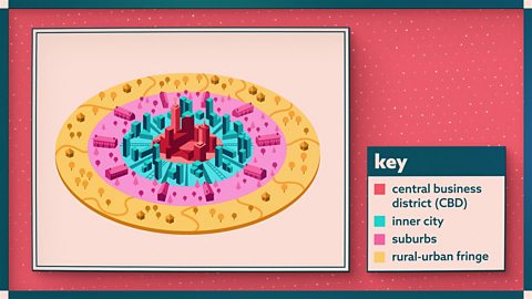
This case study will look at characteristics of land-use zones in the city and recent developments in:
- CBD (central business district)
- Inner city
- rural/urban fringe
CBD developments are seen in shopping centres and transport changes, like pedestrianisation of streets and introducing a LEZ (Low Emissions Zone).
Redevelopments in inner city areas has spread the CBD, particularly along the River Clyde:
- New housing has been created (eg Clyde Gateway Project
- New business areas (eg International Financial Services District)
- New retail and leisure (eg Glasgow Harbour and Quayside)
On the rural/urban fringe there is always pressure on the greenbelt from housing developments and new business districts.
- Business parks offer new office space outside the CBD, with cleaner environments and good transport connections (eg West of Scotland Science Park)
- Park and ride schemes allow commuters to access the CBD without facing traffic and parking issues (eg Easterhouse Park and Ride)
- New housing developments can offer larger homes with more space (eg Maidenhill in Newton Mearns)
- New business and industry districts take advantage of cheaper land for development (eg Silverburn shopping centre)
Video - urban developments
Watch this video to find out more about how urban environments in cities in the developed world are changing. Includes examples of more recent developments from Aberdeen, Dundee, Edinburgh and Glasgow.
Case Study - Glasgow
There have been many developments in recent years in different parts of cities. Many of these changes follow similar patterns in different cities.
The tables below look specifically at examples from Glasgow. If you have been studying a different city, try comparing these examples with changes you have learned about.
CBD developments in Glasgow
Shopping changes
| Change | Positive impact | Negative impact |
|---|---|---|
| Out-of-town shopping centres like Braehead and Silverburn have been built with plenty of free car parking | Indoor malls can make shopping and leisure more comfortable, compared with cold and rain in the city centre | Competition from new shopping centres has contributed to loss of business and closure of shops in the CBD. |
| New retail parks and trading estates, eg Strathkelvin Retail Park or Glasgow Fort on the edge of town | Shoppers can take home big and bulky goods in their car | City centre furniture shops and electrical stores close down or relocate to cheaper out of town locations |
| Pedestrianised shopping streets, eg Argyle Street and Buchanan Street | Safer and less polluted shopping environment | Cars are restricted to other areas and congest neighbouring streets |
| New supermarkets open 24 hours in out-of-town locations | Allow shoppers to buy everything they need and include services like opticians and dry cleaning services | Smaller city centre shops can't compete, eg butchers and fishmongers are forced to close down |
Transport changes
| Change | Positive impact | Negative impact |
|---|---|---|
| Improved public transport, eg bus lanes help to keep buses running on time | Fewer people take their cars into the city centre so less congestion | Travellers are inconvenienced if services are cancelled, eg because of bad weather |
| One-way streets, eg Hope Street | Allow traffic to flow freely and move faster | Difficult for drivers to get around the city centre if they are unfamiliar with the restrictions |
| Reduced on-street parking with multi-storey car parks, parking charges, double yellow lines and traffic wardens | Fewer cars illegally parked on streets blocking them | Expensive to park car |
| Ring roads that avoid the city centre | M8 motorway and M74 extension allow traffic to pass through city, avoiding CBD congestion | Roads are still congested at peak times. |
| Low emission zones | Cleaner air for visitors | Drivers with older cars fined if they enter the CBD. |
Glasgow, Edinburgh, Aberdeen, and Dundee all have Low Emission Zones.
Bath, Birmingham, Bradford, Bristol, Portsmouth, Sheffield, and Tyneside (Newcastle and Gateshead) operate Clean Air Zones
London and Durham have both introduced congestion charges where drivers pay a fee to take their car into the city centre.
Redevelopments in inner city Glasgow
The inner city has undergone many changes over the past decades. There have been a number of programmes put in place to regenerate the inner city areas of Glasgow. This has been ongoing since the 1970s when many old heavy industries declined and close down.
Redevelopment of inner city areas has varied in different areas:
- The CBD has expanded west, including the development of the *International Financial Services District.
- New offices have been built to the south of the river at Clyde Place.
- Development along the River Clyde has focused on leisure and business, including the SEC (Scottish Events Campus), Hydro arena, Glasgow Quay, Glasgow Science Centre and Riverside Museum.
- New housing, including student accommodation has been built along the Broomielaw and into Finnieston.
- Old tenements and 1960s tower blocks were demolished and replaced with low-rise housing in the New Gorbals.
- A mix of social and private housing is being developed at Dalmarnock as part of the Clyde Gateway project.
International Financial Services District
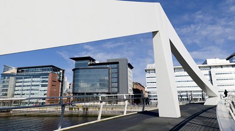 Image source, gordonsaunders/getty images
The International Financial Services District was launched in 2001. This partnership between Glasgow City Council and Scottish Enterprise was set up to redevelop the Broomielaw area along the River Clyde, and the area to the west of the city centre.
New office building were built in the place of disused industry and the area has continued to expand to the west and north. The Tradeston Bridge (sometimes called the Squiggly Bridge) was completed in 2009 to connect the IFDS to Tradeston on the south side of the Clyde. More offices have now been built at Clyde Place in Tradeston, with bases for Barclays and the Student Loan Company.
Image source, gordonsaunders/getty imagesGlasgow Harbour and Quayside
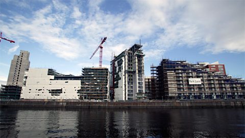
There has been a focus on regeneration along the River Clyde since the 1980s. It has involved the development of new service industry to replace the old shipyards and docks.
Initially, the SECC (Scottish Exhibition and Conference Centre) was built as a way of changing the income coming into the city, through visitors and business.
Developments in recent years include:
- Expansion of the old SECC area into the Scottish Events Campus. This includes the Armadillo auditorium and Hydro arena.
- Development of Glasgow Science Centre and IMAX cinema at Pacific Quay
- Move of BBC Scotland to Pacific Quay
- Riverside Museum and Tall Ship located at Yorkhill Quay.
The SEC in particular has led to the construction of a number of hotels, and new housing has been built nearby in Finnieston and Festival Park.
Modern apartments have been built to encourage more people to live in the city, including students and professionals. This helps to lower congestion and pollution levels.
Transport links over the River Clyde have been improved with the addition of the Clyde Arc (known as the Squinty Bridge). There has also been tree planting and landscaping to aesthetically improve the area and make it more environmentally friendly.
Glasgow Quay has been developed as a leisure outlet with restaurants, cinema, casino and ten-pin bowling to increase amenities in the area.
There are more planned developments outlined in the Glasgow City Development Plan for retail, leisure and commerce to help further improve this whole area, spread the regeneration along the river and ultimately enhance the city's economy.
Clyde Gateway Project
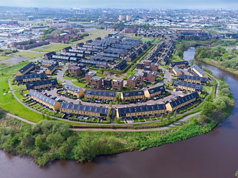
This project is focused on Glasgow’s East End areas including:
- Bridgeton
- Dalmarnock
- Parkhead
It began in 2007 and runs until 2028, as a partnership between Glasgow City Council, South Lanarkshire Council and Scottish Enterprise with funding from the Scottish Government.
As part of the Clyde Gateway Project, significant investment was focussed on a 33 hectare site where infrastructure for the 2014 Commonwealth Games was required.
The Athlete’s Village was built in Dalmarnock and after the event, these were converted into about 1,400 City Legacy Homes. Affordable, energy-efficient homes were built (or refurbished) to lower energy bills.
To help maintain the heritage of the area, where possible, existing buildings were reused and upgraded. For example, the Olympia was converted from a theatre to offices. Fifty per cent of all derelict land has been regenerated and landscaped e.g. by planting trees to make it more appealing to residents.
New businesses have set up in the area and 150 local businesses are supported directly by the Clyde Gateway Project as new business and office spaces have been created. Police Scotland moved 1100 staff to a new £25 million Dalmarnock office in 2015.
Employment opportunities have been created with skills development and training through apprenticeships. Over 3000 new job opportunities e.g. in the Emirates arena, allows local residents to earn, which in turn means they are more likely to stay in the area and buy a home.
The Legacy Hub is a new and improved community centre to meet the demands of the community and it includes every day services such as a dentist, nursery and a café Housing associations such as West of Scotland Housing Association continue to receive government grants to build more affordable housing in this area.
Recent developments on rural/urban fringe
Cities are constantly changing and growing. There is much pressure on the greenbelt from This is when the city grows and spreads out into the surrounding countryside..
This diagram shows how urban sprawl works.
Decentralisation of offices
Some offices are relocating to business parks on the outskirts of the city beside main roads for access. They are moving to take advantage of the cheaper land with room to expand. The less polluted environment helps to attract a highly skilled workforce. However, this relocation contributes to This is when the city grows and spreads out into the surrounding countryside. and land use conflicts with rural land users, eg farmers.
Examples of business parks include Glasgow Business Park in Springhill, and West of Scotland Science Park near Maryhill.
Transport changes
Many main roads, motorways and train lines link the suburbs with the city centre to allow commuters easy access to work, shopping and entertainments. Park and ride schemes have been particularly important to enable people to travel to events without taking their cars, eg football matches and arena concerts.
Examples include Patterton Park and Ride in Newton Mearns and Easterhouse Park and Ride.
Housing developments
From the 1960s onwards, new towns, eg East Kilbride, and council estates like Castlemilk, were built on greenfield sites on the outskirts of the city to combat overcrowding in the inner city sub standard housing.
New housing developments continue to add to the problem of urban sprawl today. Small villages like Clarkston have now been swallowed up by the Glasgow city boundary and farming villages like Eaglesham have been turned into commuter settlements.
Examples of recent housing developments include Maidenhill in Newton Mearns and Springhill Gardens on the edge of Barrhead.
New industry and new business districts
Industrial estates, retail parks, large supermarkets and shopping centres are located on the edge of the city to take advantage of the cheaper land, room for expansion, access links and nearby population for labour and market. Silverburn is a recent example of a shopping centre built on the greenbelt of Glasgow.
However, these developments increase urban sprawl and put pressure on the greenbelt. The impact of these developments is a decrease in farmland and a loss of wildlife habitats.
Definitions
- Commuter settlement – a place where people live and travel elsewhere for work.
- Greenbelt – the area around a city where development is restricted so that town and cities do not merge.
- Rural/urban fringe – the area at the very edge of the city beside the countryside.
- Urban regeneration – a programme designed to improve inner city areas by upgrading existing housing, building industrial estates and health centres, and landscaping.
- Urban sprawl – the growth of towns and cities spreading and taking over areas of the countryside.
Quiz
Recap
Glasgow is an example of a developed world city which has seen recent developments in:
- CBD (central business district)
- Inner city
- rural/urban fringe
CBD developments are seen in shopping centres and transport changes, like pedestrianisation of streets and introducing a LEZ (Low Emissions Zone).
Redevelopments in inner city areas has spread the CBD, particularly along the River Clyde:
- New business areas (eg International Financial Services District)
- New housing has been created (eg Clyde Gateway Project in Dalmarnock)
- New retail and leisure (eg SEC, Glasgow Quay, Riverside Museum)
On the rural/urban fringe there is always pressure on the green belt from housing developments and new business districts.
- Business parks offer new office space outside the CBD, with cleaner environments and good transport connections (eg West of Scotland Science Park)
- Park and ride schemes allow commuters to access the CBD without facing traffic and parking issues (eg Easterhouse Park and Ride)
- New housing developments can offer larger homes with more space (eg Maidenhill in Newton Mearns)
- New business and industry districts take advantage of cheaper land for development (eg Silverburn shopping centre)
More on Revision guides: urban environments
Find out more by working through a topic